 (Credit: LlamaZOO)
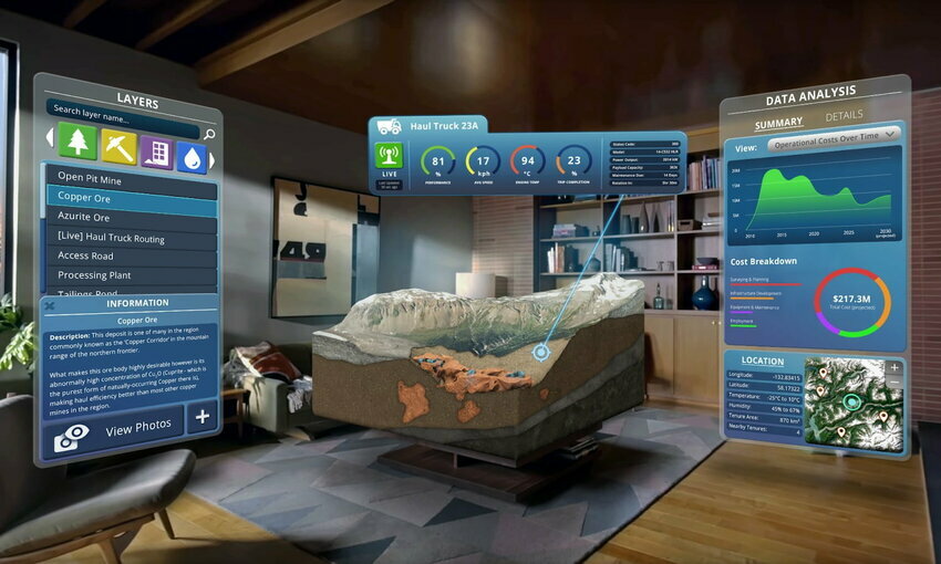
Spatial business intelligence provider, LlamaZOO, is releasing a beta of its digital twin editing software, Clarity Digital Twin (ClarityDT), which has the ability to create immersive replicas of physical assets. The software can prove useful for anything from improving manufacturing production to exploring an entire geography.
ClarityDT analyzes data from many sources, including satellite imaging and physical mapping, creating 3D replicas to help streamline operations. It contextualizes data into a unified 3D experience for often difficult to understand information, creating a single common operating picture for an entire team.
The software, specifically in combination with a given company's data platforms, aids in creating efficient data visualization. Acuity Brands connected their open data platform, Atrius DataLab, with the software to improve location awareness and provide building insights monitoring. The combined tools help companies avoid inefficiencies and errors in industrial processes and adds a spatial element to data visualization.
"For the last year and a half we've been working with LlamaZOO to explore how Atrius DataLab could be extended and visualized as a 3D spatial digital twin," said Sandeep Modhvadia, Vice President of Product Management at Acuity Brands. "The ClarityDT beta technology is a great opportunity to see this extension come to life. We are excited to continue our technology partnership with LlamaZOO so that we can offer solutions to the market that take advantage of this impressive technology."
Most remarkable is the flexibility of the new software, as it offers a wide variety of uses in industrial management and land-based decision making.
For the land and project planning sector, for instance, ClarityDT is able to provide immersive collaboration across geographies. Avoiding multiple site visits in such planning saves time and leads to an overall more efficient process. The software may also be used as a tool in visualizing areas prone to ecological disaster, supporting mitigation and prevention efforts. Governments using the software could understand the extent of damage, assess future risks, and improve climate resiliency.
Applications to participate in the ClarityDT beta program are now open for industrial and land based resource operators, and the platform will be available globally in the first half of 2024.
Editor’s note: Don’t miss the virtual Environment+Energy Leader Solutions Summit ’23 on July 18-19. Learn tangible, innovative solutions to help with sustainable transitions across industries. Speakers from companies and organizations including Schneider Electric, Cority, Jump Associates, Mycocycle, Plainsight, LRQA, the Alliance to Save Energy, and many more will share tactics and lessons that can help you solve your energy management, sustainability, and ESG challenges. Learn more about the #EESummit23, and then register today!


