
The web-based, high-fidelity dispersion simulator was originally developed by Project Canary to accurately and transparently visualize and measure emissions from one or multiple sources. It has undergone a year of controlled release testing and working with operators to quantify emissions at over 200 oil and gas facilities in North America. Now, Colorado State’s Methane Emissions Technology Evaluation Center (METEC) will perform independent evaluation of the model using single-blind controlled releases.
Project Canary has been developing its emissions quantification tool since May of 2021, and it has since been tested and modified in various ways.
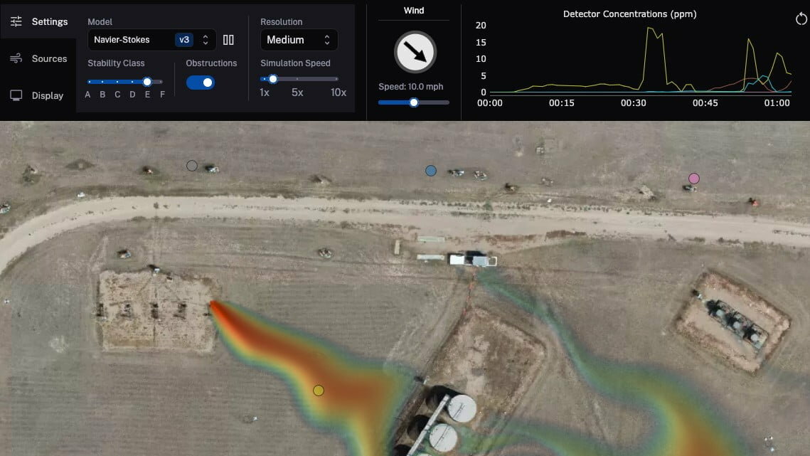
In addition to the 200 testing sites in the past year, the simulator has also gone through field testing at the Permian basin and has measured underground emissions releases from different soil types. At this stage, the tool is now able to consider a wide range of variables that may impact gas dispersion, such as wind speed, wind direction, site obstruction, and emissions rates from different sources. The METEC testing may further hone these capabilities.
“Our work with Project Canary will provide data to help refine their simulator to generate representative concentration data at receptor locations,” said Stuart Riddick, research scientist at METEC. “Measurement data collected downwind of controlled methane releases at the METEC facility will be used to tune their model in changing environmental conditions over simple and complex aerodynamic landscapes.”
As corporations and governments establish emissions reductions targets, site-specific measurement is needed to both accurately quantify emissions and improve accountability, particularly for high-emissions sites like oil and gas plants or industrial sites.
In addition to the Project Canary tool, GHGStat recently launched a satellite that is able to pinpoint carbon emissions from specific industrial sites and can make 2 million facility measurements each year. MethaneSAT also recently announced that its methane monitoring satellite will be launched next month.
Project Canary’s tool specifically aims to achieve a better understanding of gas emissions dispersion. Users can select from three modeling tools in order to view how pollution disperses differently among modeling methods.
Explore the depths of sustainability with the E+E Leader Podcast: Sustainability Unveiled.
Join thought leaders, industry experts, and innovators as they unravel the latest trends, insights, and breakthroughs in the ever-evolving landscape of sustainability. Tune in for engaging conversations that shed light on the intersection of business, environment, and social responsibility.
Catch bonus episodes featuring, “Expert Advice in 5 Minutes or Less” and “Featured News/Articles.”
Stay informed, inspired, and empowered to drive positive change. Available wherever you listen to your podcasts. Subscribe today!


